

- Home
- Products
- Solution
-
Support

-
- Let collaborators satisfaction

-
- Exceed customer expectations continue to provide products and services
-
About US

- To create the best social environment
-
- We realize that people peace, happiness, happy life for the vision
- Pearmain Mall
- Contact US

Products
Home > Products > Platform software > 5063 UAV inspection and fault analysis system of Solar /Photovoltaic plant

5063 UAV inspection and fault analysis system of Solar /Photovoltaic plant
The main defects of photovoltaic power Station are concentrated in the hidden cracks, diode breakdown, heat spots, etc. existing in the photovoltaic modules themselves. Since it is not easy to diagnose manually and real time monitor the operation status of a single photovoltaic module, the unmanned aerial vehicle (UAV) is a good choice, which is equipped with a dual-sensor camera to carry out flight detection of the photovoltaic module area, and the problematic components can be found in time with the automatic image recognition technology. Greatly Improve the fault elimination efficiency, and then enhance the power generation, fully tap the value of the power station.
Product catalogSpecification Download fileOrder online
Hardware differences:
Plan 1 : DJI DJIM350RTK + PTZ Camera (DJIH20T) + M350 customized airport
Advantages: M350 UAV model is big size, endurance time is 55 minutes, the longest flight distance is 8KM, the longest effective inspection distance is 5KM, and the wind resistance level is 7. The configured lens is with perfect performance, and the follow-up can support wind field fan inspection, blade diagonal shooting, etc. Its Airport offers 7*24h continuous flight without trouble. If subsequent wind farm inspection hardware reuse is required, consider purchasing this model.
Plan 2 : DJI Airport 2
Advantages: DJI Airport 2 has its own inspection aircraft, endurance time is 35 minutes, the longest flight distance is 5KM, the effective inspection distance is 2KM, and the wind resistance level 6. its Airport offers 7*24h continuous flight without trouble. Airport 2 is relatively cheap and requires multiple unit deployments. If only the photovoltaic part of the inspection, you can consider purchasing this model.
Hardware comparison: Hardware selection does not affect software functions.
2. Function description
It conducts inspection for photovoltaic panels, timely discover abnormal conditions in photovoltaic panels and other equipment areas, and follow the PIS principle of Advanced, Practical, effective Integration and Sustainable development. To achieve the goal of knowing, saving, seeing, calculating, commanding, decision-making, and sharing (seven can), and realize the wisdom, precision and refinement of inspection. Specific functions are as follows.
(1) UAV intelligent inspection
Using image recognition technology and artificial intelligence diagnosis algorithm combined with intelligent application terminal, the power station troubleshooting, positioning, identification and analysis, the operating status and performance of photovoltaic power station faults, hidden dangers and component quality accurate identification and comprehensive analysis and assessment, providing intelligent operation and maintenance, decision-making aid key data. To achieve the power plant photovoltaic module fault detection recall rate and accuracy rate of more than 90%
(2) Intelligent early warning
Combined with the operation characteristics of photovoltaic power stations, and through machine learning, artificial intelligence and other software algorithms to achieve the component failure prediction, to find the potential defects of equipment and power generation performance deviations and other problems, such as the partial occlusion of photovoltaic modules, boards failure, or the accumulation of dust on the surface of the limit for early warning.
(3) Inspection report automation
After the UAV inspection, the software can automatically compile the inspection and early warning report and output the results, so that the operation and maintenance personnel can find the hidden dangers and specific locations of the photovoltaic modules through the inspection report, which is convenient for maintenance and processing.
3. Reconstruction Measurement and devices
The intelligent photovoltaic inspection system consists of two main parts:
(1) Software: photovoltaic defect detection software.
(2) Hardware: 1 UltraHive®UH-MKX UAV automatic hangar system, 1 aircraft kit (DJI M350RTK), 1 PTZ camera (DJI H20T) and GPU server.
The main functions of UAV inspection module contains:
(1) Data comprehensive display interface
This page will display all the information and inspection results of the photovoltaic station, including the inspection flight generated by the projection map, photovoltaic panel partition, defect location distribution and positioning, different defect color labeling, inspection data statistics, defect data statistics, defect details view and defect report view and download.
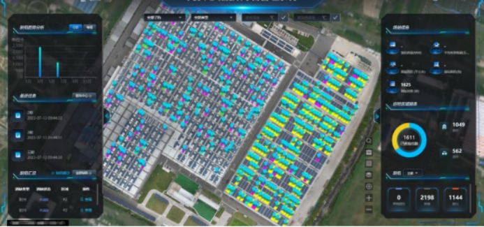
Photovoltaic area panoramic monitoring Effect
(2) Import High Definition map model of photovoltaic stations
This software can support the display of two-dimensional map (orthographic image) of photovoltaic electric field, and perform PV panel partition and module ID number based on this map; Supports panoramic map display.
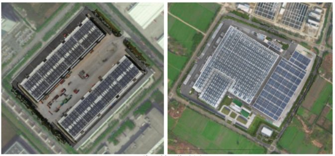
Device component ID assignment effect
(3) Precise segmentation of station group strings/components
Support automatic zone management based on the station; Support cluster / component segmentation and ID identification based on the station. The position of the photovoltaic panel can be numbered according to the area - inverter - bus box - sub string, and can also be customized according to user requirements, and the default will be named and managed based on the cluster ID after the partition.
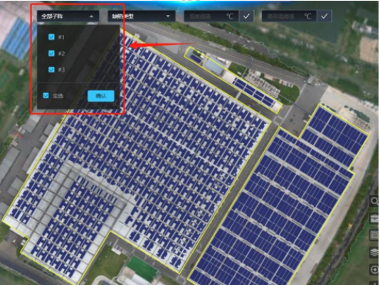
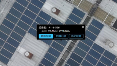
Accurate fault location and current and voltage data push
(4) Route task creation
By selecting the inspection area, setting the flight altitude, speed, overlap rate and heading of the route, Angle of the PTZ camera relative to the panel, etc., the patrol route task of the UAV is automatically generated after submitting the task, and the UAV can automatically fly according to the preset route. The UAV can load the re-planned route online, and carry out automatic flight, and support the break-point continuous flight function.

Relevant information of 5063 UAV inspection and fault analysis system of Solar /Photovoltaic plant
-
No information
You are not logged, Please log in,or registration for business users
 Related Solutions
No relevant solutions
